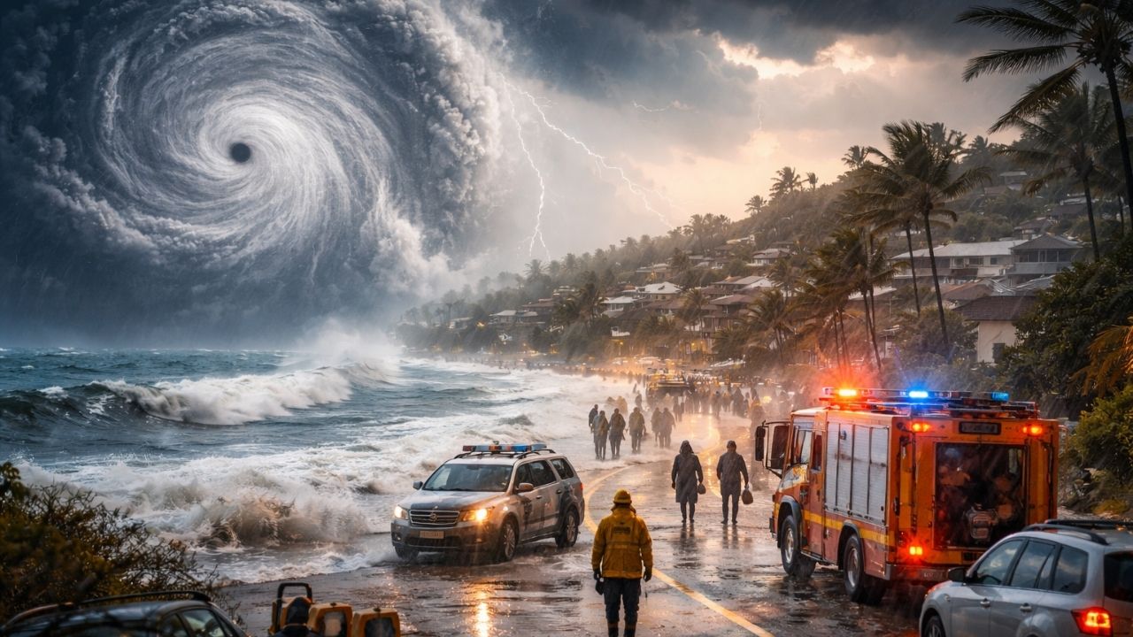
Western Australia is bracing for a dangerous weather event that officials say could rival one of the region’s most destructive cyclones in recent years.
Communities along a vast stretch of coastline are being warned to prepare now—or leave—before conditions rapidly worsen.
At the center of it all is Tropical Cyclone Narelle, a system gaining strength and drawing growing concern.
What makes this situation more urgent is not just the storm itself, but how quickly it’s evolving—and how vulnerable some areas may be.
What’s Happening With Cyclone Narelle

Tropical Cyclone Narelle is intensifying as it moves south along Western Australia’s coast. Forecasters say it is likely to strengthen into a powerful system, with the possibility—though not guaranteed—of briefly reaching category five strength.
Latest Stories
 Earth Was Once Turned Into a Fiery World by an Asteroid—Here’s What Scientists Are Discovering Now
Authorities expect the cyclone to make landfall late Friday night, most likely near Shark Bay. Along the way, large parts of the coastline are already feeling its effects, with strong winds hitting towns like Karratha.
The storm’s size is also a concern. Its wide reach means damaging winds and heavy rain could impact multiple communities at once, not just a single landfall point.
Why This Storm Feels Familiar—and Concerning
Emergency officials are drawing comparisons to Tropical Cyclone Seroja in 2021, which caused widespread destruction in areas not typically exposed to such extreme conditions.
Latest Stories
 Couple Finds Newborn Puppies Buried in Snow, Race Against Time Leads to Incredible Rescue Story
That comparison is raising alarm bells. Many homes in parts of Western Australia—especially further south—are not built to withstand cyclone-level winds. If Narelle maintains strength as it moves inland, the damage risk increases significantly.
Authorities are particularly worried about older buildings and structures that may fail under pressure from strong winds or flying debris.
Evacuations, Preparations, and Emergency Response
Officials are urging tourists to leave affected areas, especially in coastal towns. Caravan parks and campsites are already clearing out, with many people heading inland ahead of the storm.
Latest Stories
 Fishermen in France Discover Rare Blue Sea Spider Crab, Stunning Scientists and Prompting Urgent Marine Research Efforts
Emergency services are stepping up preparations. Search and rescue teams have been deployed, and crews are reinforcing flood-prone areas with sandbags. Fuel supplies are also being secured to ensure emergency operations can continue even if infrastructure is disrupted.
Local leaders are emphasizing that leaving early is the safest option for those in high-risk zones, particularly where evacuation routes may become dangerous once conditions deteriorate.
Heavy Rain and Flooding Risks Expanding
Beyond strong winds, rainfall is expected to be significant. Some areas, including Coral Bay and Exmouth, could receive between 100 to 200 millimetres of rain in a short period.
Latest Stories
 Evidence Found in China Reshapes Mars Research, Pushing Space Agencies to Reevaluate Search for Life Beyond Earth
Even Perth, far from the cyclone’s center, is forecast to receive notable rainfall, with more wet weather expected to continue into the weekend across several regions.
This combination of wind and rain increases the risk of flooding, especially in low-lying or coastal areas already prone to water buildup.
Infrastructure Concerns and Power Risks
In remote communities like Shark Bay, concerns are growing about power reliability. While renewable energy sources like wind turbines are in place, backup systems rely heavily on diesel—and any disruption could lead to outages.
Latest Stories
 A 12,000-Year-Old Discovery in Turkey May Change What We Know About Early Human Belief
Fuel demand is already rising as residents prepare, with petrol stations seeing heavy traffic and supplies being closely monitored.
Authorities say they are confident in current fuel stocks but are taking additional steps to ensure emergency crews have access if conditions worsen.
What Could Happen Next
The next 24 to 48 hours will be critical. If Cyclone Narelle strengthens further or maintains intensity as it approaches land, the risk of widespread damage increases.

Even if the system weakens slightly before landfall, its size and rainfall potential mean impacts could still be significant across multiple regions.
Officials continue to monitor the situation closely and are urging residents to stay updated, follow safety advice, and act early rather than wait.
FAQs
1. Where is Cyclone Narelle expected to make landfall?
Current forecasts suggest landfall near Shark Bay late Friday night, though the exact location could shift.
Latest Stories
 Detroit Red Wings Sign Jacob Bernard-Docker to Two-Year Deal, Prioritizing Defensive Stability Over Prospect Rotation
2. How strong could the cyclone become?
It is expected to reach at least category four strength, with a small possibility of briefly intensifying to category five.
3. Which areas are most at risk?
Coastal regions including Exmouth, Onslow, and Shark Bay face the highest risk, but inland areas may also experience strong winds and heavy rain.
4. Why are authorities comparing it to Cyclone Seroja?
Because Seroja caused major damage in areas not used to cyclones, and similar conditions could occur again.
Latest Stories
 HBO Unveils First Harry Potter Series Teaser, Confirms 2026 Release as New Cast Steps Into Iconic Roles
5. Should residents evacuate?
Authorities advise evacuation for tourists and people in high-risk or vulnerable areas, especially where homes are not cyclone-rated.
6. How much rain is expected?
Some areas could see 100–200mm of rain, while Perth may receive around 40–50mm, with more rain over the weekend.
7. What should residents do now?
Secure loose items, prepare emergency supplies, stay informed through official updates, and consider leaving early if advised.
Latest Stories
 Rain Interrupts Sheffield Shield Final After Victoria’s Fast Start Puts South Australia Under Pressure